 |
| Waterfall Canyon (Ogden, Utah) |
Ah, Waterfall Canyon! Everyone who has ever been in the Boy Scouts anywhere in Weber County, Utah has done this hike at least once. A fairly short yet fairly steep hike, this little trek takes about 2 hours total and leads to a very pretty waterfall. It remains one of the most popular hikes in the Ogden area and the trail is very heavily used. This is a good hike for kids that are about 6 years and up (as long as they like to hike .... the upper part of the hike can be tricky if you're trying to carry kids around!). My daughter loves this hike and always asks when we can do it again.
The trail begins at the 29th street trailhead in Ogden. This is the same take-off point for anyone wanting to hike to Malan's Peak or Malan's Basin. The trail starts out by taking a couple of steep bends up to hit the Bonneville Shoreline Trail (which traverses along the base of the Wasatch Mountains in various segments from Brigham City to Provo). Once on the trail, you head south along the Bonneville Shoreline for about a half mile or so.
 |
| Smiley Face Water Tank! |
You know you're getting near the mouth of the canyon when you run into a couple of old rusty water tanks just below the trail on the west side. I call the tank on the north side the "smiley tank" because someone has painted a huge yellow smiley face on the top of it. It's a bit hard to tell what it is from the photo above, but if you look at any recent aerial photos of the area it's a dead giveaway.

Just beyond the smiley tanks the trail curves to the left and heads east into the canyon itself. The next half mile or so is pretty steep but the trail is good. Up to this point, the vegetation has been pretty open, with mostly sagebrush and scrub oak around. As you head into the canyon, the vegetation remains sparse and open, but as you can see from the photo above it thickens up pretty quickly. At this point in the trail, you can hear the stream from the waterfall, but it is far below in a ravine on the south side of the trail.
 |
| Rocks and Trees in Waterfall Canyon |
After about a half mile, the trail and stream come together. At this point, you truly enter the forest and the trail becomes more irregular and rocky. The trail crosses back and forth over the stream a couple of times and continues to climb rapidly as you get deeper into the canyon.

I've always liked this rock. You hit it about halfway up the canyon. It sits high on the cliff on the north side, and always looks like it's about ready to fall right off the side of the hill.

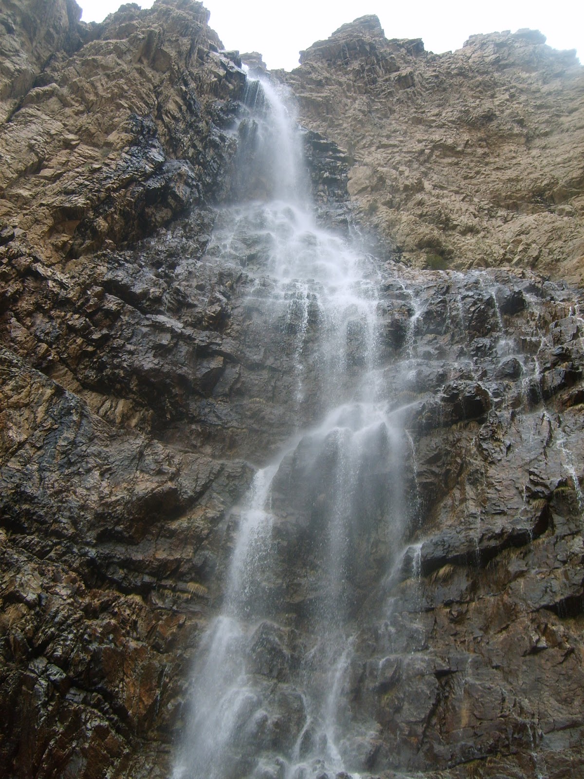
And before you know it, you're there! The waterfall cascades down over hundreds of feet of rock, lands in a pool, and heads down the canyon. The area around the waterfall itself is the steepest terrain of the entire hike; it's a bit tricky to find a good spot to sit. The views are incredible, though, and it is definitely worth the trek up the canyon.
The area around the waterfall is shaped like a big semicircle with cliffs on the north, east and south sides, and the trail you came up on the west. The waterfall runs down the cliffs to the north, and the ground in the circle is angled at about a 20% slope running from southeast to northwest. The ground is shale-covered, and footing can be a bit tricky, especially for very young kids.
Optional Combination with Malan's Peak Trail: At the very top of the circle (in the southeast corner), there is a small break in the cliffs that you can climb through. From here you can make your way around to the top of the cliff, up above the crest of the waterfall, and into Malan's Basin. If you go this way, I don't recommend taking kids younger than eight or ten with you because the terrain gets very steep and there is no trail.
Once you make it up into Malan's basin, you will quickly find the trail that leads back around to the top of Malan's Peak. From there, you can head down the Malan's Peak trail which will lead you back to the 29th street trailhead in the opposite direction from where you started. This combo trail is a lot of fun, and I've done it three or four times in the past. However, if you do plan to combine the trails, I would highly recommend you go up Waterfall Canyon and down Malan's Peak, and not the other way around since the steep shale areas above Waterfall Canyon would prove very tricky to negotiate coming down.
Trail Stats:
Trail Type: Out-and-back
Total Length: 2.6 miles
Total Vertical Feet: 1,100
Average Slope: 16.3%
No comments:
Post a Comment